|
Coronavirus delays GPS III SV03 launch until June
The United States Space Force’s Space and Missile Systems Center has decided to reschedule the launch of GPS III SV03 (GPS III-3) from Cape Canaveral Air Force Station to minimize the potential of COVID-19 exposure to the launch crew and early-orbit operators.
|
|
|

Schriever stays operational despite COVID-19
Despite the worldwide COVID-19 response, the 50th Space Wing at Schriever Air Force Base continues to execute its critical operations, while ensuring the proper steps are taken to maintain airmen’s health and well-being.
|
|

Orolia to host industry discussion on PNT Executive Order
Orolia will host an industry discussion online at 2 p.m. ET on May 7 on the Positioning, Navigation and Timing (PNT) Executive Order. The PNT Coffee Talk event will be held online and is open to those interested in learning more and discussing this national priority from the industry and government perspectives.
|
|

Final steps underway to operationalize new GPS M-code signal
The final steps to fully enable the ultra-secure, jam-resistant military code (M-code) signal on GPS are now underway. As part of the U.S. military’s effort to modernize GPS, the U.S. Space Force has been steadily upgrading its existing GPS Ground Operational Control System (OCS).
|
|

United Technologies and Raytheon complete merger
Raytheon Technologies Corporation announced the successful completion of the all-stock merger of equals transaction between Raytheon Company and United Technologies Corporation on April 3.The deal follows the completion by United Technologies of its previously announced spin-offs of its Carrier and Otis businesses.
|
|
|

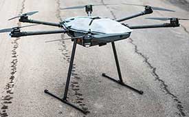
Fortem Technologies ships DroneHunter F700 C-AUS
Fortem Technologies Inc. is now shipping its artificial intelligence (AI)-enabled F700 DroneHunter. The F700 is a safe, effective deterrent against a rising number of careless and criminal drones, the company said.
|
|
|

Cobham secures UK contract for GNSS anti-jamming
Cobham Aerospace Connectivity will research advanced GNSS anti-jam techniques for the United Kingdom Ministry of Defense. The research contract was awarded by the Ministry of Defense’s Defence Equipment and Support office.
|
|
|
Smarter Decisions From Above: How to Optimize Aerial & Drone Survey Programs
Date: April 30
Sponsored Content by: Nearmap
Summary: Using intelligent aerial data helps geospatial and surveying companies make profitable business decisions. Full-scale aerial surveillance with real location intelligence helps optimize productivity and improve accuracy. In this webinar, you will discover how to build an aerial imagery program that includes complementary content, from UAV to fixed-wing aircraft.
Speaker: Brian Isbell, technical client services lead, Nearmap
|
|
|
|
|