2019 Wildfire Risk Report from CoreLogic Analyzes Western U.S. Damage and Risk
October 16, 2019 by Susan Smith
In September, CoreLogic released their 2019 Wildfire Risk Report that analyzes the top regions, states and metro areas at risk for wildfire damage, including number of at-risk homes and their estimated reconstruction costs. The report also includes a breakdown of 2017 and 2018’s major wildfires, which were quite extensive through the western United States. The report focuses on homes in the western states including Arizona, California, Colorado, Idaho, Montana, New Mexico, Nevada, Oklahoma, Oregon, Texas, Utah, Washington and Wyoming.
Some important facts from the report include (from company materials):
- The report found nearly 776,000 homes with an associated reconstruction cost value of more than $221 billion are at extreme risk of wildfire damage.
- The Los Angeles, Riverside and San Diego metro areas ranked as the top three high-risk areas, respectively with more than 42% of residences at high-to-extreme wildfire risk.
-
- These regions make up more than 51% of the total RCV of the top 15 metro areas analyzed.
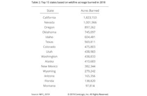
- In 2018, the highest number of acreage burn occurred in California (1,823,153 acres burned), Nevada (1,001,966 acres burned) and Oregon (897,262 acres burned).
- 2018 was a record-breaking wildfire year with 8,767,492 acres burned—roughly equivalent to 74 of the 75 largest cities in the United States combined.
-
- This marked the 6th highest total since modern historical records began in the mid-1900s.


