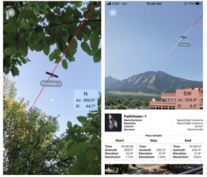
Recently in the news we have seen a lot of satellite imagery depicting fires and hurricanes and their resultant damage, as well as satellite imagery of wartorn areas of the world such as Afghanistan. Of course this type of imagery is not new, but new ways of being able to display and gain greater understanding of a situation are invaluable to those tasked with analyzing such data.
Greenbelt, Maryland’s Orbit Logic’s SpyMeSat mobile app now includes an augmented reality (AR) interface that provides better awareness of overflying imaging satellites. The AR view overlays the orbit and position of satellites that can image your location, providing a better understanding of satellite viewing geometry and potential obstructions; e.g., to know if an image taken by that satellite of your position would be obscured by a tree or a building. The AR interface also displays relevant information about the satellite and its capabilities, that includes the timing and dynamic geometry of the pass as well as the resolution achievable by satellite sensors.
New OGC Pilot will accelerate our collective readiness for accessing, fusing, and analyzing climate and non-climate data to contribute to the global push for achieving climate resilience.
The Open Geospatial Consortium is offering sponsorship opportunities to support the OGC Climate Change Services Pilot 2022 (CCS 2022). The objective of the Pilot is to accelerate our collective readiness for accessing, fusing, and analyzing climate and non-climate data to contribute to the global push for achieving climate resilience. Responses are due by December 31st, 2021.

The OGC CCS 2022 Pilot will develop a reliable foundation for decision-ready data services for use in all kinds of climate actions. For this purpose, OGC members engaged in this pilot will develop a series of demonstrators that show the exploitation of climate data as part of a standards-based process that starts with raw data from satellites and climate change models and, through several processing and integration steps, produces decision-ready data in support of achieving climate resilience.


