View here!


OCTOBER 21, 2020
 
  INSIGHTS
 
Photo: Sonin
 
How drones are helping with COVID-19, first response applications
 
By Tony Murfin
A solution for these COVID-19 days, getting to injured people really fast and potentially even faster first response applications are all new drone applications featured in this month’s UAV summary.

 
Read More
 
  NEWS
 
Photo: gorodenkoff/iStock/Getty Images Plus/Getty Images  
Aceinna joins ST Partner Program for precise positioning
 
Aceinna has joined the STMicroelectronics Partner Program to make its IMU and RTK precise positioning solutions available to those working on next-generation solutions that safely and accurately position autonomous vehicles.
 
Read More
 
View here!
 
View here!
 
Image: NASA  
Optical navigation enables sample collection from asteroid
 
NASA took on a Herculean precision positioning task that culminated Oct. 20 with a spacecraft sampling the surface of an asteroid from a 5-meter area — a NASA first.
 
Read More
 
 
View here!
 
Photo: J2R/iStock/Getty Images Plus/Getty Images  
SkyBitz and Coretex join to track cold trailer shipments
 
Telematics company SkyBitz has announced a strategic technology partnership with fleet logistics solutions provider Coretex.
 
Read More
 
View here!
 
View here!
 
Photo: MStudioImages/E+/Getty Images  
Geotab Keyless helps car-sharing fleets pool assets
 
Geotab has unveiled Geotab Keyless, a platform solution that integrates a secured digital key function with a comprehensive and data-driven fleet management product.
 
Read More
 
 
View here!
 
Photo: SpaceX  
Aborted launch of GPS III SV04 results in hardware analysis
 
The aborted launch of the fourth GPS III satellite has sparked an investigation into the SpaceX Falcon 9’s Merlin engine.
 
Read More
 
View here!
 
Image: RNT Foundation
 
Precise time for all: Paper calls for resilient national timing
 
A new white paper sponsored by the Resilient Navigation and Timing Foundation discusses the need for and implementation of a reliable and resilient national timing architecture that will include space-based assets.
 
Read More
 
View here!
 
Headshot: Rodrigo da Costa  
Rodrigo da Costa begins role as new GSA director
 
Rodrigo da Costa took up his duties as executive director of the European GNSS Agency (GSA), soon to become the EU Space Programme Agency. Learn about his new role and job duties.
 
Read More
 
View here!
 
Image: Sapcorda  
Sapcorda expands GNSS augmentation service
 
Sapcorda Services is now testing its GNSS augmentation services for the L-band signal in North America and Europe for safety-critical navigation in autonomous vehicles and machinery.
 
Read More
 
Image: UAVOS
 
UAVOS control system for HAPS takes on unstable air
 
UAVOS Inc. has performed a series of successful flight trials with High Altitude Pseudo Satellite (HAPS) ApusDuo, testing its unique control system.
 
Read More
 
Photo: Robotic Research  
Dead-end? Robotic platoon can now reverse with trailers attached
 
Robotic Research has added Retrotraverse to its AutoDrive-M autonomy kit. Read more about the kit, which is equipped on the U.S. Army’s Palettized Load System logistics trucks.
 
Read More
 
Screenshot: Javad GNSS
 
Javad offers RTPK option for surveyors with Triumph-LS
 
Javad GNSS introduced a new solution, Real-Time Post-processed Kinematics, at Intergeo Digital 2020.
 
Read More
 
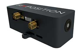
Photo: FixPosition  
Vision-RTK sensor debuts at Intergeo Digital 2020
 
Fixposition has launched the Vision-RTK positioning sensor, a compact centimeter-accurate solution with high reliability and availability in environments that are challenging for traditional GNSS. 
 
Read More
 
  FROM GPS WORLD MAGAZINE


Seen & Heard: The new Mayflower, the Africa split
 
“Seen & Heard,” a monthly feature of GPS World magazine, examines an autonomous Mayflower trimaran and predictions of when Africa will split into two continents, among other news stories involving the GNSS/PNT industry.
 
Read More


Launchpad: Drone parachute, GNSS modules, antennas
 
Check out a roundup of recent products in the GNSS and inertial positioning industry, including a GNSS antenna, multi-rotor drone and more.
 
Read More
 
Cover photo: Samuel King Jr./United States Air Force
 
  UPCOMING WEBINAR
 
The Need for Resilient PNT Services to Ensure Safe and Secure Transportation Infrastructure
 
Date: Oct. 22
Sponsored Content by: Microchip
 
 
Summary: Over the past two decades, transportation-critical infrastructure sectors have widely adopted the use of GNSS-derived PNT to support their safety-critical operations. GNSS PNT’s extreme position and timing accuracy enables significant capacity and efficiency improvements, and this accuracy has been a primary driver for this evolution. However, the availability, integrity and continuity of PNT services are essential to maintain the safety and security of these systems and its users. This webinar will explore how GNSS is used by the transportation industry and discuss emerging strategies to build in monitoring, security and resiliency to provide an assured PNT framework.
 
 
Speaker:
Guy Buesnel, CPhys, MInstP, FRIN PNT security technologist, Spirent
Greg Wolff, senior product line manager, frequency and time systems, Microchip
Mitch Narins, principal consultant and owner, Strategic Synergies

 
Register Here
 
View here!
 
Logo: GPS World Logo: Twitter  Logo: Facebook  Logo: YouTube  Logo: LinkedIn  Logo: Instagram

You are subscribed to Professional OEM as newsletter@newslettercollector.com.

Forward to a friend | Change your subscription preferences | New subscriber sign-up
To leave this mailing list, simply unsubscribe. | Refer to our Privacy Policy.

GPS World is a property of North Coast Media, LLC.
1360 E. Ninth St., 10th Floor, Cleveland, OH 44114
© 2020 North Coast Media. All Rights Reserved.
Reproduction in whole or in part is prohibited without written permission.
 
View here!View here!