MARCH 23, 2021
 
  TOP STORIES
 
 
Image: metamorworks/iStock/Getty Images Plus/Getty Images  
Industry members, non-profit urge Congress to fund GPS alternatives
 
In separate letters to members of the House of Representatives and the Senate, seven companies and a non-profit urged Congress to support alternative positioning, navigation and timing systems (PNT) with the “necessary funds and other appropriate policy tools.”
 
Read More
 
Image: Bhaskar Kundu, et al. Scientific Reports. Feb. 2, 2021

 
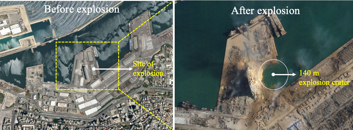
GNSS data show Lebanon blast affected ionosphere
 
A 2020 explosion in Lebanon’s port city of Beirut led to a southward-bound, high-velocity atmospheric wave that rivaled ones generated by volcanic eruptions. Now, calculations by Hokkaido University scientists in Japan have found that the atmospheric wave from the blast led to electron disturbances high in the Earth’s upper atmosphere.
 
Read More
 
View Here!
 
  MORE NEWS
 
Logo: CGSIC  
Minutes posted for meeting on GPS documents
 
The Air Force Space and Missile Systems Center has published minutes for the 2020 Public Interface Control Working Group (PICWG) and Open Public Forum help, which took place on Sept. 30, 2020, for several NAVSTAR GPS public documents.
 
Read More
 
View Here!
 
Photo: Spirent Federal  
Spirent doubles update rate of flagship GNSS simulator
 
Spirent Communications has added premium enhancements to its GSS9000 Series of GNSS constellation simulators.
 
Read More
 
Logo: ION JNC
 
Registration open for ION Joint Navigation Conference 2021
 
The Institute of Navigation (ION) announces that registration for the Joint Navigation Conference (JNC) is now open.
 
Read More
 
Photo: Hexagon | NovAtel  
Hexagon | NovAtel introduces new marine-certified GNSS receiver
 
The MarinePak7 multi-constellation, multi-frequency receiver has been specifically engineered to receive Oceanix Correction Service from NovAtel, providing horizontal accuracy up to three centimeters (95%) in a marine environment.
 
Read More
 
Click Here!
 
Photo: Phase One 
 

Phase One announces P3 drone payload for asset inspection
 
Phase One, a developer of digital imaging technologies, has announced the P3 Payload, a versatile solution designed for fast, efficient and safe inspection of critical infrastructure with an unmanned aerial vehicle (UAV).
 
Read More
 
Photo: Tallysman
 

Tallysman introduces two VeroStar marine precision GNSS antennas
 
Tallysman Wireless is offering two new VeroStar marine antennas to its line of GNSS products. Both antennas support L-band correction signals.
 
Read More
 
Photo: Microchip

 
SyncServer S600 now defends against GPS jamming, spoofing
 
Microchip Technology has integrated its BlueSky technology signal-anomaly detection software into its SyncServer S600 Series network time server and instruments.
 
Read More
 
View Here!
 
Photo: svarshik/iStock Editorial/Getty Images Plus/Getty Images
 

Israel Railways to use InfiniDome’s GPS monitoring solution
 
InfiniDome Ltd., a GPS security company, is joining with Israeli partner Focus Telecom, in a new country-wide project with Israel Railways.
 
Read More
 
Photo: Cepton
 
Lidar-based system for high-speed tolling coming soon to US highway
 
An electronic tolling system that uses high-performance lidar sensors from Cepton and a vehicle identification solution from Red Fox ID is expected to be deployed on a major highway turnpike crossing multiple states in the United States.
 
Read More
 
  FROM THE PRO OEM + UAV NEWSLETTER
 
Photo: NEC Labs/Antonio Albany
 
 
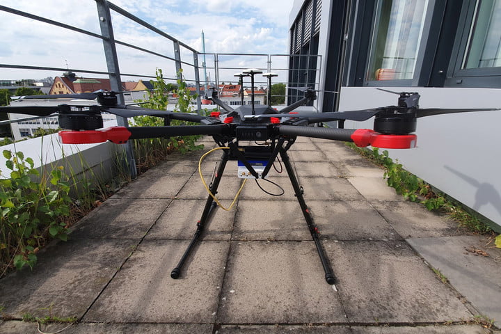
Search-and-rescue drone debuts, FAA issues remote ID rule
 
By Tony Murfin
GPS World columnist Tony Murfin looks at developments regarding a potential drone solution for finding disaster victims, the Federal Aviation Administration (FAA) issuing its remote ID rule and the Boeing Loyal Wingman's maiden flight in Australia.

 
Read More
 
  UPCOMING WEBINAR
 
Collecting Remote Asset Locations Using GNSS, GIS Apps and Laser Offset Mapping
 
Date: March 25
Sponsored content by: Laser Technology Inc.
 
 
Summary: Map more, move less. By combining laser rangefinders with your GNSS receiver, smart device and preferred GIS mapping app, you can collect remote assets safely and efficiently. Learn about the different mapping workflows and the offset position accuracies you can achieve with equipment you already own.
 
Speakers:
Derrick Reish, Senior Product Manager, Laser Technology Inc.
Mike George, GISP, sUAS, GIS Director, Project Manager, DDSI Global
 

Register Here
 
View Here!
 
Logo: GPS World Logo: Twitter  Logo: Facebook  Logo: YouTube  Logo: LinkedIn  Logo: Instagram

You are subscribed to Navigate! Weekly as newsletter@newslettercollector.com.

Forward to a friend | Change your subscription preferences | New subscriber sign-up

Look forward to us each Tuesday? Don't forgot to also subscribe to the magazine or renew your subscription.

If you wish to leave this mailing list, simply unsubscribe. | Refer to our Privacy Policy.

GPS World is a property of North Coast Media, LLC.
1360 E. Ninth St., 10th Floor, Cleveland, OH 44114
© 2021 North Coast Media. All Rights Reserved.
Reproduction in whole or in part is prohibited without written permission.